|

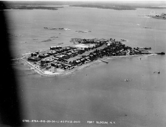
When the U.S. Army Corps of Engineers began its demolition project in 2004, remnants of Fort Slocum covered Davids Island. These remnants comprised the Fort Slocum Historic and Archeological District.
The historic district included roughly 80 buildings and building ruins. It also had about 20 other major constructed features, technically called structures. The structures and their ruins included docks, seawall, fortification, storage area, monument, flagpole, roads, walkways and outdoor facilities like the athletic field and the Parade Ground.
The Fort Slocum historic district was the relict of an Army post that played an important role in New York’s military history in the 19th and 20th centuries. It illustrated the design of Army posts during this period, and its buildings displayed the Army’s adaptation of popular American architectural styles at one of its installations.
Eligible for the National Register of Historic Places
During planning for the demolition project, the Corps of Engineers inventoried the buildings and other features of the historic district and evaluated their significance. The Corps concluded the district was eligible for the National Register of Historic Places.
The National Register is the U.S. government’s list of historically-significant properties of many different types. Federal agencies such as the Corps refer to the register and its criteria of eligibility when deciding whether a particular property might be affected by their projects or actions.
Project evaluations like this are required by law. The key law for federal agencies is Section 106 of the National Historic Preservation Act. This law and its regulations require agencies to evaluate the effects of their activities on historic properties, and agencies need to find ways to avoid or offset their project’s negative effects.
Section 106 regulations also direct agencies to consult with the State Historic Preservation Officer, or SHPO, about their evaluations. When the Corps determined that the Fort Slocum Historic and Archeological District was eligible for the National Register, New York’s SHPO reviewed the finding and agreed.
Mitigating Demolition in the Historic District
The Corps of Engineers’ evaluation of its planned demolition project on Davids Island found the work would affect the historic district adversely. The demolition project would remove most of the district’s key features, such as the historic buildings, greatly diminishing its overall historical qualities.
The Corps took several steps to mitigate, or offset, this adverse effect. It signed an agreement with the City of New Rochelle, Westchester County, and New York’s SHPO detailing a mitigation plan.
One of the most important parts of the plan was to make a detailed permanent record of the buildings and other structures in the historic district before they were demolished. Digital photographs played a key role in making this record, but the Corps also shot video footage of the buildings and prepared written descriptions of them. Another important element was to interview some of the men and women who lived, worked or served at Fort Slocum between the 1920s and the 1960s. This Web site itself is one of the mitigation measures.
Earlier Studies
The studies of the Fort Slocum Historic and Archeological District were not the first investigations of the district’s history, architecture and archeology. Similar work was begun in the 1980s during planning for the demolition of Fort Slocum and the residential redevelopment of Davids Island.
After the earlier studies New York’s SHPO determined that 11 buildings and the Mortar Battery were individually eligible for the National Register. The eligible buildings were:

- Four officers’ quarters (Buildings 1, 6, 9, and 10);
- Three barracks (Buildings 55, 68, and 69);
- the Administration Building (Building 13);
- the Post Exchange (Building 70);
- the YMCA (Building 71); and
- the Chapel (Building 108).
The earlier studies also identified a Native American archeological site on Davids Island and found that it, too, was eligible for the National Register.
The planners of the 1980s project also developed a mitigation plan, but its terms were not carried out because the redevelopment project was not approved.
After Congress began to appropriate funds for the demolition of Fort Slocum in 2004, these earlier studies provided important background information to guide the Corps of Engineers. They helped the federal government act as a conscientious steward of the historic resources on Davids Island.
|


 Historic District
